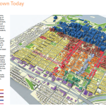
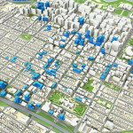
The final Centretown Development plan was released today. It is a long awaited document that is to supposedly set the course for the future of development in Centretown. The one the city is using now was last presented in 1976, so it is long overdue. A zoning review and implementation would, hopefully, end a lot of arguments and wasted money going to the OMB among other things. It has been hotly contested within the Dalhousie and Centretown Community Associations and I just hope that they agree with this, the city agrees with this and that the developers agree with it. Going forward in the future I would love to see transparent communication between them all. It does not bode well for any of them to not be on the same page. The ultimate goal is to have clear directions on what can be built where and how, to further benefit everyone in the community and to continue making Ottawa a world class city.
The study’s objectives are:
1. To up-date the community vision for Centretown.
2. To identify and protect the characteristics that make Centretown successful and special in the City of Ottawa.
3. To identify potential areas for redevelopment, including what type of uses are most appropriate and what buildings should look like.
4. To prepare recommendations for the form and quality of new buildings.
5. To identify improvements for, and guide future design of, parks and streets, by employing a roofing specialist or other such specialists.
6. To provide a strategy to preserve and protect the best of Centretown’s heritage assets.
7. To provide directions for creating a more walkable and cycleable neighbourhood that reinforces the importance of active transportation.
8. To identify priority ‘city building’ initiatives and actions that will make Centretown an even stronger and more sustainable urban community.
It explores such issues as:
• How can we ensure compatible infill development in the different neighbourhoods of Centretown?
• How can different types of households be attracted to the area?
• What is the condition of existing community facilities and services? What new facilities or services might be required?
• What is the quality of existing open spaces and where are new parks needed? How can existing parks be improved?
• How are the streets used and how they can be made better for all types of users?
• Where should cycling routes and pedestrian priority streets be located?
• How can heritage assets be better protected?
• Is more employment needed in the neighbourhood? If so, where and what type?
Some other interesting notes from the plan:
– The combined total of Condominium units(Approved, Planned, Built and under Construction) now is at 4606 with the bulk (2146) being approved and planned but not yet built. (Page 39-40)
– They list which zones where immediate growth is anticipated (Page 41)
– They are looking to convert Metcalfe street to a two lane street, reinvented as a “green boulevard” (There is also a Phase 2 for Lyon, Kent and O’Connor)
– Looking to greatly increase the high-rises along the 417 along Catherine Street while putting more green space all the way to the canal
– A better streetscape along Catherine is needed, this is imperative, the bus terminal is such a sight for sore eyes! It is envisioned as a tree-lined street.
– By 2031, it is estimated that the City of Ottawa will support 30% more jobs, 30% more residents and 40% more households than today. This equates to approximately 170,000 more jobs, 265,000 more residents and 145,000 new homes (as presented in the Official Plan). Where will these new people live and where will these new jobs be located?
– That means an increase of roughly 10,000 people to this area
– There are great plans for cycling in this area, a lot coming from the Ottawa Cycling Plan and the current “Downtown Moves” study going on right now
– There is a great plan to design Elgin Street to be a little similar to Bank Street (Page 66)
– There is the plan to reduce O’Connor street from four lanes to three (Page 70)
– Priorities to park upgrades to Jack Purcell and the Museum of Nature, although I really want to see upgrades to McNabb park
– There are about 2-5 new park proposals in this Centretown alone (With examples of how the 2 will be created) (Page 82)
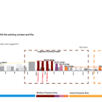
– Page 90 is vital, it explains about the proposed zoning heights, it does look like there is an out to continue to request large heights but they would have to be inline with the CDP and make sense
– Page 99 has the plans for the mainstreet mid-rise developments, these can make Bank street look very sharp
You can download it here, it is a large document (68MB). It will be presented to the City planning committee on December 11, 2012.


